
- (Introduction)
- Coastal waves have significant importance due to their multifaceted implications (like beach erosion).
•Numerical models are treated as a useful tool for obtaining wave data along with buoys and satellites, especially in terms of supplementing the spatiotemporal limitations of observational data.
•In coastal regions with complex marine environments, wave deformation occurs due to factors such as topography and currents, which is identified as one of the causes that decrease model accuracy.
•This study aimed to improve the accuracy of wave models by gradually adjusting the input data (offshore wave boundary, wind input, and hydrodynamic conditions) and model coupling methods for Gyeonggi Bay, Yellow Sea.
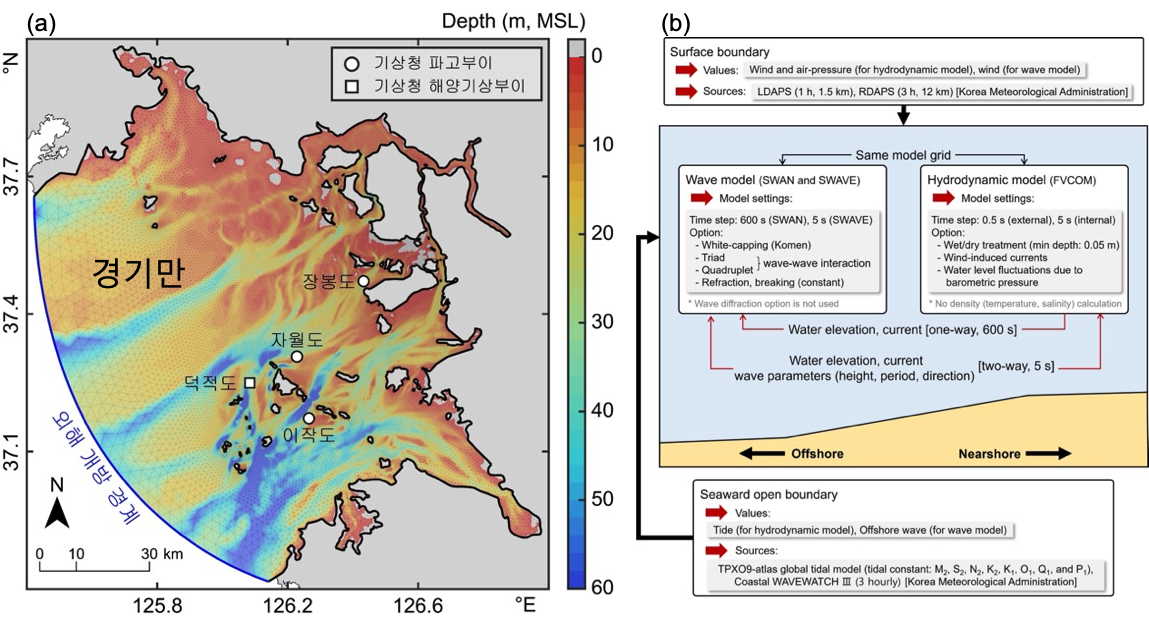
(a) Model grid system, bathymetry, and four wave observation points in Gyeonggi Bay. The blue line indicates the model open boundary where the boundary conditions of the tide and offshore wave are entered. The observation data is provided by the Korea Meteorological Administration (KMA) and points are as follows: three wave buoys, located at Jawoldo (JW), Ijakdo (IJ), and Jangbongdo (JB); one weather buoy at Duckjeokdo (DJ). Model bathymetry based on the mean sea level (MSL). The gray shaded area is the area where the water depth is less than 0 m with respect to the mean sea level. (b) A schematic diagram for model simulation (input data and numerical schemes)
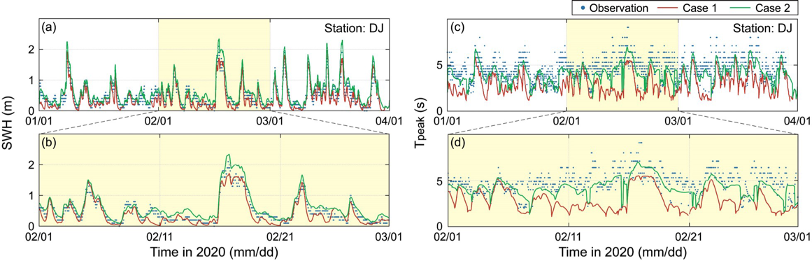
Time series of modeled and observed (a and b) SWH and (c and d) Tpeak at DJ. Case 1 shows results without wave boundary conditions, while Case 2 incorporates wave boundary conditions. For clarity, a zoomed-in view of the one-month time series for SWH and Tpeak is presented.
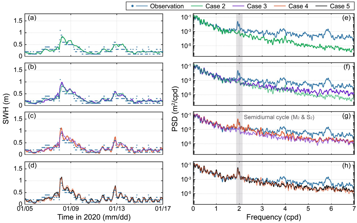
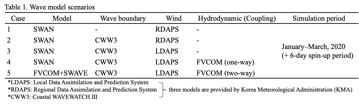
Observed SWH at JB is presented alongside modeled SWH results that sequentially control boundary condition (Case 2), wind input (Case 3), hydrodynamic condition (Case 4), and coupling method (Case 5). Refer to Table 1 for details on model input for each case. (a–d) Time series showcases January 5–17 for clarity. (e–h) The power spectral density (PSD) represents both modeled and observed SWH over the 3-month simulation period, processed using fast Fourier transform analysis. For clarity, the results were smoothed using a Parzen window to 0.110 cycles per day (cpd). Vertical gray shading indicates the semidiurnal tidal cycle. Except for Case 2 (a and e), subsequent cases are overlaid with previous ones with adjusted opacity.
(Summary)
• The accuracy of the wave model decreased as it moved from the offshore side (DJ) to the inner bay side (JB).
• When wave boundary conditions were applied at the offshore open boundary (Case 2), the model's accuracy for significant wave height (SWH) and peak wave period (Tpeak) improved, particularly at DJ and JB, which are located offshore.
• When high-resolution wind input data was applied (Case 3), the model's accuracy improved for short periods (>2 cpd).
• When ocean current conditions were applied (Case 4–5), wave deformation at tidal (semi-diurnal) periods was reproduced.
• In the future, it is expected that the model's accuracy can be further improved through two-way coupling with high-resolution atmospheric models and the nesting technique in regional-scale wave models, indicating the direction for further research to enhance the model.
- 사업명
- 씨그랜트사업 5단계
- 발주처
- 해양수산부